
INSTALL 'WAZE' FOR A BETTER DRIVING EXPERIENCE
ARE TRAFFIC CAMERAS IN CYPRUS REALLY FOR ROAD SAFETY OR TO CREATE REVENUE?
Two main questions are always at the forefront of the debate when it comes to CYPRUS TRAFFIC CAMERAS. The first is, ‘Are traffic cameras installed purely for road safety or to raise funds?’ The second is ‘Are traffic cameras really effective at reducing speeding drivers or preventing accidents on Cyprus roads?’ With both questions provoking much debate, there seems to be no clear answers! One thing is certain, however, and that is that the rapid deployment of TRAFFIC CAMERAS has led to the majority of drivers questioning not only their effectiveness but also their validity.
TWO SIDES OF AN ARGUMENT
As the CYPRUS TRAFFIC CAMERA debate rages on, arguments both for and against are constantly and rigorously debated every day throughout the island’s courts. Several of these drivers, who went on to win their legal arguments, successfully argued that certain cameras offered little, if any, road safety. They also went on to explain in detail how, in some cases, TRAFFIC CAMERAS actually helped to cause some traffic accidents. They successfully illustrated how TRAFFIC CAMERAS often caused other drivers to suddenly stop or drive erratically. Others also maintained that they believed that these cameras had been installed to simply create revenue, and that this was the main reason why they were not enforced properly. Cypriot authorities, however, whilst acknowledging the extra revenue for government coffers, maintain that Cyprus roads are much safer now that TRAFFIC CAMERAS operate across the island.
OFTEN CONTESTED IN COURT
Several drivers to date have used these debates to support their legal cases. Their overal belief that TRAFFIC CAMERAS are helping to create an unfair playing field for all drivers on the island has been rigorously expressed and, in most cases, proven. In addition to this, several drivers state that the current system, instead of penalising bad drivers, unfairly catches out otherwise careful and considerate road users. Many have stated that most drivers are now playing a game of cat and mouse on most roads where these cameras exist. For example, some drivers have stated that once they know where static speed cameras exist, they then simply slow down for that section of road and then speed up again thereafter.
A RECENT SPOTLIGHT
The controversy surrounding the management of TRAFFIC CAMERAS has also led to several drivers successfully contesting their fines in court. It has been noted that the majority of road speed limit changes are not properly signposted across the island. In addition to this, it has been proven on several occasions that most mobile cameras do not use proper signage according to highway rules. TRAFFIC CAMERAS have also recently been in the spotlight because they have been fining people for stopping on the white lines. This has resulted in drivers receiving fines for simply getting too close to the stop line at a junction. This is often argued as a contradiction of European Law, which states that a vehicle has to completely pass a red stop light to receive a fine.
EVENING UP THE PLAYING FIELD
WHAT IS WAZE?
Some drivers in Cyprus have now turned to technology to help even up the playing field. The majority have chosen to install the GPS navigation tool Waze on their smartphones. Owned by Google, this app, once installed, can be easily used to provide real-time traffic information, route planning, and turn-by-turn navigation.
REGULAR UPDATES
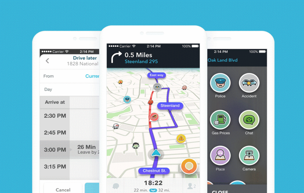
Waze not only helps drivers find the best routes for their destinations, but also helps identify fixed and mobile traffic camera locations across the island. The regular real-time updates help drivers navigate Cyprus roads more safely. It also provides drivers with advanced warnings of changes on the road ahead. Drivers are also notified of ad hoc changes, such as traffic congestion and accidents on their route. This allows them more time to shift lanes or even take a detour.
KEY FEATURES
Navigation & alternative routes: Waze can be set to offer the quickest route to any given location. It will then issue verbal as well as visual instructions along the route. It can also be set to offer alternative routes that will avoid congestion, hazards, or TRAFFIC CAMERAS.
Avoiding traffic cameras: Waze can be set to plan a route that avoids both static and mobile traffic cameras.
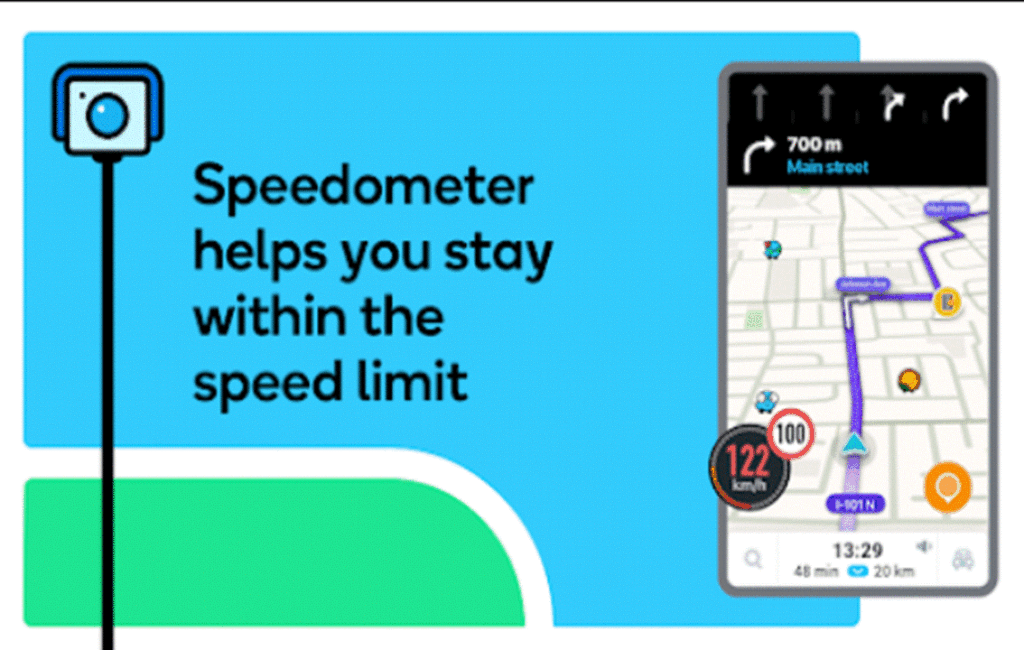
Speed limits: Waze can be set to update the driver of any sudden decrease in speed limits in advance.
Hazard detection: Waze can be set to alert the driver to any speed bumps, sharp turns, and toll booths.
Parking: Waze will supply information on car parks and available parking spaces in real-time. This feature will also advise drivers of all costs and whether the parking facility is covered or open to the elements.
Roundabout navigation: Waze can be set to advise drivers on how to properly navigate a roundabout on any given route. This feature will point out when to enter, when to switch lanes, and where to exit a roundabout.
HOW DO I USE WAZE?
1. Install the Waze app from your mobile phone’s respective App Store.
2. Open the Waze app on your smartphone and then sign up for a Waze account.
3. Allow Waze to access your location so it can provide you with real-time traffic information.
4. Enter a destination into the destination section.
5. Choose the preferred route based on the options provided by Waze.
6. Start the navigation and follow the visual or voice-guided instructions to reach your destination.
Waze will proactively report all road incidents along the intended route. These include traffic accidents, hazards, traffic cameras, and police presence along the intended route.
Google Maps now integrates Waze incident reports
Although real-time navigation, using incident reports from Waze, has now been added as a new function in Google Maps, Google maintains that both applications will remain independent. This move comes after Google recently disclosed plans to share data across other applications in an effort to enhance its own platforms.
Waze’s thorough road condition reports will now proactively offer additional navigation support for drivers who use either of these applications. The additional navigation support includes real-time reports on TRAFFIC CAMERAS, police presence, and road closures. Drivers are then given the option to actively verify these conditions by updating or confirming the status of these reports. This, in turn, assures other drivers of accurate and current information.
These reports are then shared not only as Waze reports but also as Google Maps notifications, spreading the real-time information to a greater extent. The distinctive features of Waze, which set it apart from Google Maps, are valued by its sizable community of over 500,000 contributors. Likewise, users are also found to prefer its other unique features. Information sharing across both platforms is thought to be Google’s attempt to improve user experience. It is intended that both platforms moving forward will utilise these advantages while keeping their individual identities.